| |
THE MARS / EARTH CONNECTION
by Klaus Totzek
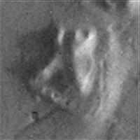
One day in summer 1994, I accidentally got a book in my hands, written by the author Johannes von Buttlar, about the FACE on MARS. My first opinion was, that this is nonsense, quiet impossible. But when I saw the first picture of that FACE, I changed my opinion because it was of such an anatomical perfection that it could not have been formed naturally. My ideas of the connection between EARTH and MARS originated out from the following considerations:
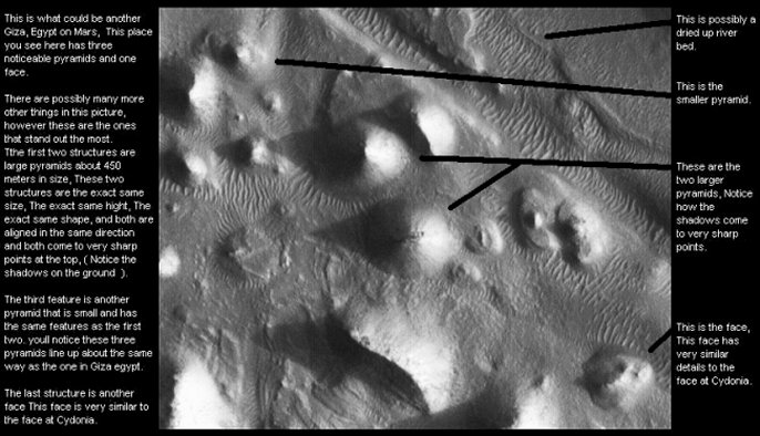
1. In Cydonia there not only is existing the FACE - like structure, but others too.
2. The regularity in their geometry indicates to an artificial origination. The structures in their totality seem to give a message to their observer.
3. The works Richard C. Hoagland and Dr. Mark Carlotto have proved that in my eyes. So we have to clarify who the builders were and what were the reasons of their origination. There are three theories about that. One is, that a former mankind must have built the structures. The hypothesis which is following out from this is, that mankind must be older than we believe today. Hoagland in his book "The Monuments on MARS" supposed that there was a connection between EARTH and MARS in past of mankind.
4. Because there are pyramids on EARTH and appear to be on MARS as well; it could be possible that both sets of pyramids originate from the same source. This was the first indication to the connection between Giza and Cydonia.
5. The second and probably the most important one came from the orientalist Zecharia Setchin. In his book "The 12th. Planet" he has written about, that the sumerians have known about the existence of all the planets inside the solarsystem. Their names always decribed real properties of the planets, which were confirmed by our spacecrafts today. When the names of, for example, the outer planets are correct descriptions of their real properties, so the names of MARS as A.PIN (=there, where to set a correct course) and LACH.MU =(God of destruction) must be correct too.
6. So I studied the monuments to find any indications to prove these names. One of the results is that it is possible to calculate the orbit data of planet EARTH with the help of the monuments of Cydonia.
7. The sumerian Epic of Creation and the egyptian myth of OSIRIS are nearly complete identical. Both they are describing the same story of the origination of the solarsystem and the mankind in connection with the destruction of a former planet which became a risk for EARTH and MARS.
8. Out of this follows, that the egyptian God HORUS is identical with planet MARS. And that means, that all the Gods inside of the myth are celestial bodies. In the same way as in the Epic of Creation. So this myth describes a very special cosmical event.
9. So it was possible to equate the structures of Cydonia with the Gods of this myths. The alignments and the distances of all the structures makes it possible to interpret the structures as a pictorial representation of the cosmical event what is described by the myth of OSIRIS: The fight between HORUS = MARS and SETH = D & M PYRAMID. And the origination of the FLAMMING EYE OF HORUS therefrom.
10. Ancient egyptian texts speak about the Pyramids of Giza as models of the most important parts of heaven and simultaneous they have a reference above their names to both the most important actors of the myth of OSIRIS. These are HORUS and SETH. Out from the combination of that and the idea, that HORUS and MARS are celestial bodies whereby HORUS is MARS the connection between EARTH and MARS originates from. In addition to that I found out, that the combination of all the original measurements of the Pyramids of Giza are an exact image of the polar circumfences of EARTH and MARS. One of the results for the model of MARS especially is circumfence of 40,87� latitude, the position of the D & M. So the Pyramids are a giant indication to find the 40,87� latitude on planet MARS.
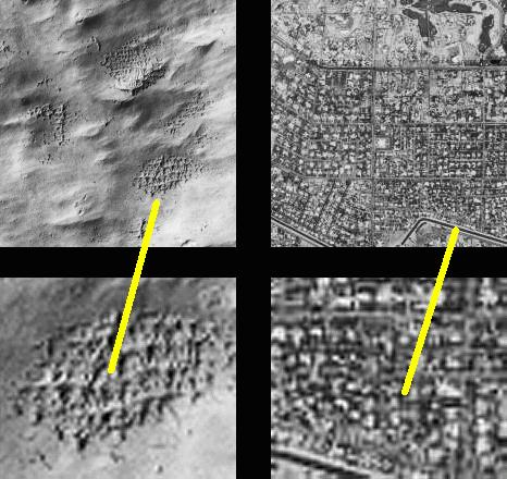
To the left is a city grid of mars to the right is a
city grid of a major city in our country again see the similarities??? In
theory mars and earth i believe are alot alike. |
EARTH / MARS orbit connection
If we suppose a cut through both the orbits of the planets MARS and EARTH, and situating it in this way, that EARTH and MARS do approach to minimum distance, yeilds the following.
Because the orbit of MARS has an inclination of 1,85� to the orbit of EARTH, at one time MARS is situated above and one time below EARTH. At first we can connect both the center points of the planets together. The length of this line is 55,96 mio. km.
This connection line on EARTH is situated close above the latitude position of the Pyramids of Giza. If we would change the actual inclination of the axis of EARTH from 23,45� to 23,18� , this line would run exact through the Pyramids. The variation of the inclination not unusual. The inclination differs from approximate 21� to 24� during a time of 25.920 years and in a superior period of 40.000 years. This is called precession, this is used to determine data of the past and is rseponsible for the existence of the eclptic. Of interest is, that the EARTH has had the inclination of 23,18� at least in the year 10.399 B.C. In the same year there was a perihelical opposition of the planets.
According to that the Cheops - Pyramid is pointing to the latitude position of the D & M Pyramid on planet MARS in the year 10.399 B.C. and is vindicating in this way the name of the SPHINX as IMAGE OF THE GOD HORUS as marker for the same year. (please have a look to Stargate of Giza) For planet MARS we have the same conditions. The connection line even so is situated close above the northern latitude of 40,87�. If we change the inclination of the axis of MARS from 25,2� to 34,07�, the line is running through the D & M Pyramid too. According to the US scientist Hal Masurski, this has happened in past too. The axis of MARS is swinging from approximate 15� to 35� during a time of approximate 2,2 million years.
Out of this it is possible to calculate at what a time at last the planets have had these necessary inclinations.
The axis of MARS was inclinated to that value at least approximately 1,7 millions of years ago. The results of the changed inclinations of the axis� and the inclination of the connection - line of about 6,8� to the orbit level of EARTH are the latitude positions of the pyramids on both the planets.
D & M PYRAMID 34,07� + 6,8� = 40,87�, so the result is the exact latitude position of the D & M Pyramid. CHEOPS - PYRAMIDE 23,18� + 6,8�, so the result is the exact latitude position of the Cheops - Pyramid.
HYPOTHESIS
Embedded in
both Ancient Sumerian and Ancient Egyptian mythology is the
"tale" of a stray comet that destroys a planet.
The Ancient
Sumerians have the Legend MARDUK and TIAMAT and the Ancient Egyptians have
OSIRIS and SETH.
TIAMAT /
OSIRIS are the names for the former planet between MARS and JUPITER.
MARDUK / SETH is the comet described by these ancient legends that
destroyed on impact TIAMAT / OSIRIS, the ancient planet of our solar
system.
Billions of
years ago, a former planet we call TIAMAT / OSIRIS was completely
destroyed by the comet = MARDUK / SETH. The fragments of the shattered
planet TIAMAT / OSIRIS along with comet MARDUK / SETH crossed the orbits
of the inner planets i n cyclical periods. There presence became a great
danger to the remaining planets of our solar system. In a time, after
millions of years, the remaining fragments of planet TIAMAT, together with
fragments of SETH smashed down onto MARS = HORUS / A.PIN
(The reference word A.PIN is according to Secharia Zetchin, one of the two
ancient sumerian names for planet MARS. The name A.PIN means: THE PLACE,
WHERE TO SET A CORRECT COURSE)
.
So parts of
MARS were thrown out, off the planet, by the shock-waves of this impact.
These parts
of HORUS became the "Flamming Eye of Horus".
Then, 60 to
65 million. of years ago these fragments smashed down onto EARTH and
destroyed the first of mankind. But not all. Some of them escaped to
planet MARS.
There they
built up the Monuments as a giant pictorial representation of this event.
As a
gigantic warning to mankind.
500,000
years ago the humans from planet MARS returned to the survivors of the
mankind of planet EARTH as the "Gods falling down from the
heaven" , known as the Anunakies. As Gods they told the humans from
EARTH about the events in the past. But packed into myths.
They formed
a new mankind, as a lot of world myths say.
Then about
12.500 years ago another cosmical catastrophe must have happened.
Either more fragments of planet TIAMAT or probably fragments of
"The Flamming Eye" of HORUS smashed down onto EARTH.
This one
was the mechanism of the great flood in our past. In that time the the
Pyramids of Giza must have been built as a sign to the monuments on planet
MARS and a marker of the year the world has been originated new after the
destruction by the great flood.
So the
Pyramids became the Horoscope of the Birth of the World and simultanous to
that they are alignmented to the Pyramids on MARS, which are speaking from
the first catastrophe 60 - 65 millions of years before. Both the Monuments
on EARTH and on MARS are written in the same cosmical signpost. Out of
that the connection between MARS and EARTH is originated.
|
|
|
What's So Unique About Cydonia?
By "R. Daniel Woolman" Ph.D, in an
epic-length post on the "In Search Of" mailing list.
What is so unique about Cydonia? Geologically it is a mixture of fractured,
desert plains containing numerous mesas (flat-topped eroded prominences)
with varied craters typical of natural landforms throughout the solar
system. But at latitude 41 degrees North, longitude 9 West lie a collection
of features which some observers believe are anything but natural. Research
conducted by a small group of scientists in America since 1979 has
suggested a most exciting possibility - the remains of artificially
designed structures.
Mankind's last wholly successful voyage to Mars was NASA's robotic Viking
mission in 1976. Twin orbiters and landers investigated the geology,
chemistry, meteorology and possible biology of the Red planet. Whilst soil
chemistry tests were ambiguous, more than 50,000 digital images of Martian
geomorphology were returned from orbit. Most of the planet has now been
mapped to a resolution of 100m, and, in some places, 10m. Scientists
continue to analyse these pictures, inferring details of geological,
climatological and - most controversially - biological evolution from them.
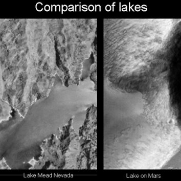
There is ample evidence that the Martian climate was in the past more
benign than today. Eroded river channels, evidence of glaciation and
perhaps even ancient lake and sea beds have all been seen in Viking images.
An ocean may have occupied most of the northern hemisphere. There has been
speculation that the features at Cydonia lie on the edge of this ancient
northern sea. Certainly if the Cydonia remains are artificial, proximity to
water would be expected. Water and oxygen may have existed in the area
abundantly over one billion years ago.
Photographic interpretation plays a key role in generating hypotheses
concerning Mars's past evolutionary history. Ejecta blankets, comprised of
material thrown out by meteorite impacts - and with icy flows surrounding
their craters - hint at locations with ice or permafrost beneath. The width
of ancient valleys can be gauged from 3- dimensional maps (generated from
originally 2-D images) and the volume of floodwaters which once occupied
them estimated. The heights of volcanoes and depths of canyons can also be
shown in startling detail in computer flyby simulations. This kind of
research is the province of planetary geologists and geomorphologists.
Similar techniques - shape-from-shading (computerised 3-D image generation
from shadow depth) and stereoscopic imaging (generated by overlaying two
images of the same area taken from slightly different perspectives) - have
also been applied to Cydonia. New interpretative tools like fractal
analysis, used to determine the probabilities of non-natural features
occurring in a landscape, have also been brought to bear. Fractal analysis
highlights any possibly artificial objects due to their non-fractal nature
(i.e. they stand out by having a different mathematical signature from the
background terrain). When the technique was tested on Viking imagery, the
results suggested certain features were strongly non-fractal, and thus by
implication, non-natural.
Those studying the Cydonia region have identified a number of objects which
appear to share certain architectural, artistic and archaeological
characteristics not intrinsic to geomorphological formations. The most
obvious formation was termed the Face because of its similarity to one. The
DiPietro and Molenaar (D&M) pyramid and City are also terms frequently used
when nearby landforms are described. These names are used solely for
research purposes and do not ascribe any function to the objects under
investigation.
Discovered by National Aeronautics and Space Administration (NASA)
personnel in July 1976, the Face was originally dismissed as a "trick of
light and shadow" when shown to journalists at the Jet Propulsion
Laboratory (JPL) in Pasadena, California. Project scientists claimed that
later images of Cydonia revealed nothing.
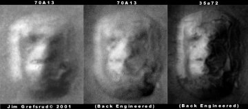
The Face was rediscovered in 1979 by Vincent DiPietro and Gregory Molenaar,
computer engineers under contract at NASA's Goddard Space Flight Center,
Maryland. DiPietro had become intrigued with Viking frame 35A72 labelled
"Head" filed in the archive. Looking for further information on the
geological explanation and analysis of the feature, he found nothing.
Initially DiPietro and his partner Molenaar called for further
investigation of the 2.5km wide Face and the apparently vast pyramid-like
structure - approximately 500m high and nearly 3km long - on frame 70A13
nearby, later termed the D&M pyramid after its discoverers.
They first developed a computer processing method called SPIT (Starburst
Pixel Interleave Technique) to enhance the images, then tested the
integrity of the method on Landsat photographs of the Earth. Although they
presented their findings in a technically responsible and scientific
manner, calling for verification of their results, they were generally
ignored by the very scientists who should have been most interested.
Despite having been shunned by the mainstream planetary establishment,
undaunted, they set up their own research organisation Mars Research, with
physicist Dr John Brandenburg.
DiPietro and Molenaar's findings were further developed by the pioneering
work of former NASA consultant Richard Hoagland in the early 1980s.
Hoagland was one of the men behind the interstellar plaques - designed to
be understood by any alien life-forms who might discover them - aboard the
Pioneer 10 and 11 probes to Jupiter, Saturn and beyond. An extremely
controversial figure in the US space community, he promotes radical new
ideas many find difficult to accept. With a background in subject areas
like archaeoastronomy, Hoagland was also something of an outsider to the
planetary establishment. He had originally accepted NASA's explanation of
the Face without question.
Hoagland discovered a collection of pyramidal mounds to the southwest of
the Face (termed the City) and containing the Fort, an unusual object
apparently with straight walls and an open central area. He also calculated
that Martian solstice alignments at Cydonia would be fulfilled every
500,000 years or so, later revising this to 330,000 years. Departing from
the usual planetary landform analysis techniques, he examined the features'
possible spatial orientations to one another. He also commissioned sculptor
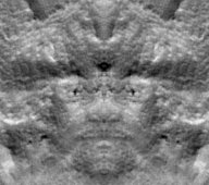
Kynthia Lynne to create an analogue clay model of the Face and surrounding
terrain. When compared with the independent computer studies conducted
there was strong correlation. Part of Kynthia's model can be seen on the
cover of Hoagland's book "The Monuments of Mars".
Results of the early work on Cydonia are found in anthropologist Randolfo
Pozos's book "The Face on Mars: Evidence for a Lost Civilization?", an
account of the computerised conference that took place in late 1983 and
early 1984 between Hoagland, DiPietro, Molenaar, Brandenburg and others. As
well as exploring the technical research conducted on Viking image mosaics,
Pozos approached the highly speculative subject of extraterrestrial life
from religious and philosophical perspectives, examining the profound
implications should Mars indeed have once held advanced life.
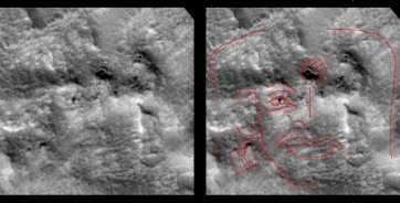
The next researcher to address Cydonia was Dr Mark Carlotto, former
employee of a Boston company occasionally involved in US government-related
work. Dr Carlotto examined Viking imagery in 1986/7 using
shape-from-shading, disproving the "trick of light and shadow" theory. He
noted the possibility that teeth were present in the mouth of the Face, and
that these were not artifacts of imaging, appearing in pictures taken at
two different sun angles. Estimating the Face at around 2.5km long, 2km
wide and 400m in height, Carlotto further noted crossed symmetrical lines
on the forehead. He also applied the fractal analysis technique two years
later. In 1991 Carlotto published a book about his work "The Martian
Enigmas", where he called for Mars Observer, NASA's most recent Mars probe,
to re-image Cydonia.
In 1988 Erol Torun, a geomorphologist and cartographer with the US Defence
Mapping Agency in Washington DC, published a cartographic and geometrical
analysis of the D&M pyramid. He concluded that the internal angles and
symmetry were unlikely to occur in a natural mountain, and that no known
erosional process could produce such a regular formation. Torun has also
worked with Hoagland developing his theories. Finally former planetologist
and NASA astronaut corps member Brian O'Leary (at one time on the selection
list for a manned mission to Mars) also published work on Cydonia in 1990,
independently reviewing Carlotto's work in the Journal of the British
Interplanetary Society.
The history of the Cydonia research - and NASA's attitude towards it, up to
and including the loss of the Mars Observer spacecraft in August 1993 - are
well documented in the 200 page McDaniel Report. Author Stanley McDaniel,
Philosophy Professor Emeritus at Sonoma State University, California,
details how NASA failed to seriously consider the research and potential
importance of the issues raised.
McDaniel argues that the space agency ignored or avoided the research,
failing to justify its criticisms. The narrow SETI (Search for
Extraterrestrial Intelligence) methodology assumed and adopted by NASA was
the radio-search model - i.e. evidence of extraterrestrial life could only
occur via Earth-based radiotelescopes. Yet surely it is incontestable that
potential artifacts on nearby planets need a clearer photographic
examination? In view of this point, it seems strange NASA is unwilling to
consider it, though there have been recent signs that this attitude may be
changing.
The most recent work on Cydonia was completed in 1995 by Professor McDaniel
and Dr Horace Crater, of the University of Tennessee Space Institute. They
published a mathematical analysis of the small mounds in the vicinity of
the Face and City, their method being to discount the random placing of
these mounds.
If the objects in Cydonia are artificial how could we learn more about
them, beyond obviously re-imaging the area with optical sensor systems? One
approach might be to use a technique known as radar remote sensing. This
was used with great success on NASA's Magellan mission, which recently
mapped Venus using Synthetic Aperture Radar (SAR). Radar remote sensing has
a number of advantages over conventional optical systems. Firstly, the
illumination of a scene is generated by the satellite itself, in the form
of microwaves. These have several unique properties: they can pass through
clouds and weather systems unaffected; they can be used regardless of day
or night (and hence are of great interest to the military) and can, to some
extent, help to show what surface textures and materials are composed of.
On Earth for example, power lines and railways show up clearly on radar
imagery, being linear metal features they are strong signal reflectors.
A radar system deployed to study Cydonia might be used not only to map the
topography, but also provide spectacular 3-D views similar to those of
Venus generated from Magellan data. It would also be able to peer beneath
the Martian desert revealing the geological substructure as well as any
possible ruins.
The European Space Agency has examined instrumentation - including several
radar systems - for possible Mars missions in a 1989 study document. Radar
applications on Earth have made some surprising findings. The space shuttle
radar revealed ancient Mayan canals when the shuttle flew over Central
America in 1981. Completely covered in jungle they were invisible from the
ground. Archaeologists subsequently visited the site and verified the
shuttle's discoveries. The discovery of the ancient city of Ubar, in the
Middle East, was also assisted by space shuttle radar imagery. At the time
of writing, Dr Michael Malin, President of Malin Space Sciences - the
company building the camera for Mars Observer's replacement - has said he
will re- image Cydonia. This marks a subtle change from an individual who
has sole control of what objects the camera photographs, and originally
showed no special interest in the Cydonia region. The Mars Global Surveyor
is due to commence mapping Mars in early 1998.
What could be the solution to the mystery of Cydonia? Conventional
explanations for the Face involve natural forces blindly sculpting the mesa
into its near-symmetrical form. The pyramids have been compared with
driekanters or ventifacts - rocks and stones polished and faceted by
windblown sand. Yet if the landforms are natural it obviously asks a great
deal of nature. How could the same winds produce such differing forms so
close by, and what about the precise mathematical angles claimed in the D&M
pyramid?
We can but speculate on the implications should the features turn out to be
artificial, but theories put forward amongst those advocating an artificial
origin suggest that Cydonia might provide evidence for it; for example:
1.An ancient indigenous civilization which arose on Mars billions of years
ago, when the planet was more Earth-like; perishing, for reasons not yet
fully understood, when the climate changed.
2.Visitors from beyond the solar system who colonized Mars when it was more
habitable, either dying out, migrating to Earth or returning home when the
climate changed.
Or do the Martian artifacts really seem so unfamiliar?
Why assume they are really so ancient?
Could the real answer to the mystery of Cydonia have something to do with
us?..
....and, with this I believe we can now discuss this region without the
burden of psuedo-scientists attempting to wish a history and background
that may, or may not exist.
Cydonia is not going away! It has been around for a long, long time and
there is no reason to believe it is going to disappear in the next week,
month or year. I am simply not certain at this time, that anything other
than natural formations of land structures through natural erosion took
place.
Imaging will occur over this region once the Mars Surveyor arrives. It may
take some time; the first images may not be from the high-res imager, but;
if there are real scientifically 'provable' artificial structures as
proposed by those mentioned above, you can well bet that NASA/JPL WILL
obtain the best images possible. And, if there was any real scientific
proof of unnatural 'artificial' structures in the Cydonia region today you
can well bet NASA/JPL would place it on its highest priority. There is
simply no proof. Scientists can not avoid a true mystery, they can avoid
one that is obviously false.
Perhaps NASA/JPL are doing what scientists should do and that is to better
understand how Mars came to be what it is today. With a clearer
understanding of Mars and its geological history then perhaps we will be
better suited to explore the anomalies associated with the Cydonia region.
|
|