|
|
||

Around the year of 1565 a 175 years before the construction of Fort Matanzas another tragedy occurred in the Matanzas Inlet which was the massacre of the French Huguenots. A large French Force commanded by Jean Ribault had left their settlement of Fort Caroline in Spanish claimed territory which is near present day Jacksonville to attack the Spanish at their new settlement known as Saint Augustine back then called San Agustin! During this fleet a terrible hurricane shipped wrecked the men further south scattering the fleet and when the Spanish discovered the French on a nearby beach they ordered them to surrender, give up their Protestant faith and accept Catholicism. The men did surrender because they had no food, no weapons but they refused to give up their faith. So the Spanish massacred 245 Frenchman as trespassers and heretics near the inlet which is named Matanzas which is a Spanish word for a place of many massacres. Blood was spilled on these beaches and these men never had a fair chance. This confrontation led to 235 long years of Spanish control. Of course Saint Augustine was built all because the King Of France had Fort Caroline built on the St. Johns River under the direction of Rene De Laudonnier. King Philip II of Spain sent Pedro Menendez De Aviles to build a settlement here to control the French from trespassing on their newly found land. Beforehand Saint Augustine was just a military Spaniard outpost till it became a large city. While the massacre was occurring Menendez and some of his men seized the empty Fort Caroline and of course the race for who controlled Florida was won by the Spanish. In 1569 a wooden watchtower and a hut were built just north of the Matanzas Inlet which housed 6 soldiers 14 miles south of Saint Augustine. These soldiers would take turns scanning the ocean waters for enemy threats. If they sighted a ship a runner, man on horseback or a log canoe would be sent to alert St. Augustine to the north. In 1733 Gen. James Oglethrope found an English colony in Georgia on land claimed by Spain. In 1740 he began the siege of St. Augustine by blockading the Matanzas River. With hurricanes aproaching, alck of naval support and a well prepared St. Augustine Oglethorpe withdrew his forces and men. But because of the siege Gov. Manuel de Montiano need a better more equiped watchtower then the wooden one they had. Montiano called upon an engineer named Pedro Ruiz De Olano to build a strong stone structure. From 1740 to 1742 Fort Matanzas was standing strong and build on a two acre island which has grown two over two miles the last few hundred years known as Rattlesnake Island. The stone structure sat in the middle of nowhere which included around seven soldiers. They would patrol the waterways surrounding the inlet and also reside here. The purpose of the fort was to put a lock on the back door and way into Saint Augustine. If you could aim the cannons down the river there would not be one ship who would dare try advancing up the river. The fort was strong enough to withstand cannon fire and difficult to invade by land with all the marshes in the area. In 1750 five cannons were mounted to cover all approaching directions. Today two cast iron cannons that were mounted in 1793 remain. At the gundeck there was a water cistern that was capable of holding 1,500 gallons of water. Sadly the English gained control of Fort Matanzas as well as the rest of Florida by the treating of 1763 and they used this fort also as a watchertower. Eventually by 1821 Florida was ceded to the United States and the entire interior of Fort Matanzas was in ruins. In 1924 the fort was proclaimed as a national monument and in 1933 control of the fort was transferred to the War Department to the National Park Service so it could be restored closest to its original design. The only way to the fort is to take a ferry to Rattle Snake Island which is called the Matanzas Queen II which holds 22 passengers making trips to this fort daily. They say over 50,000 people a year visit this fort and once your on it and the island it really is like stepping back in time at least its the closest you will ever get in my opinion unless time machines are invented. One of the men who has been driving the ferry for 24 years says not much has changed accept the island surrounding the fort. The island just a few acres in size is almost 2 miles long and a half of mile wide. Over time storms, tides and man have caused the island to expand. Walking on the island is dangerous it was not meant to be hiked on in my opinion since its full of thick sand, saltwater marshes that are so deep you can sink up to your knees in them, and woods with plenty of rattle snakes when the weather warms up. Lets not forget the saltwater crocodiles which roam the channels that cut threw the island. The tallest parts of rattle snake island contain woods with many trails that lead to dead ends or are fallen dead trees. Some of the best sea shells I have seen in FL are on this island. The whole place is fairly preserved and untouched by man. Its rumored that every 25 to 50 years the island does go underwater we did find signs of that so definitely not a great place to hike when the tide starts to come on in. I will not disclose the information as to how I got on the island but its either swim or take a boat on out to the island an explore. This probably was one of our greater adventures we really went threw the extremes and explored not only the fort but the island as well knowing the risk that are involved. As far as ghost photos well I wish we were more productive with the paranormal here but when your legs are stuck in quick sand or your busy seeing the supernatural you really have no need for a camera. Each Halloween ghost tours are given in the Matanzas Bay by boat where stories are told about the soldiers who still haunt the fort. Today not many stories are told and the answer is simple A. The only way to reach it is by ferry B. At night its closed unless you are granted special permission like for example a ghost tour and C. Who is crazy enough to conquer this fort and its island lol? Okay maybe us but still point being that its one of these haunted places I feel that does not get the attention it deserves. They say that local fishermen who sail in these waters have strange sightings of a green light emerging from the surface. Once the light breaks the surface it turns white and a beautiful face emerges and disappears into thin air. Then others say they have seen the waters turn blood red after sunset and the sands of the bay are also said to have a reddish tint when stepped on or stirred up in the shallows. We did get to hike on the beach and of course we did not see bloody sand but I did see a glowing light in the woods on the island and it vanished before my eyes. Like Andrew one of our members of our team said hey Rick you could really die out here. I mean honestly when you put it all together this fort was built for a reason and one reason only which was that it was nearly impossibly to penetrate. If the alligators, salt water crocs, and rattle snakes did not kill you then the terrain and location would do you in. So with great news to our fans I bring to you Fort Matanzas. If you wish to see its sister fort located northward check out the link here Click Here: Fort Castillo De San Marcos © By Lord Rick-AngelOfThyNight
Daytime Fort Shots From & To Across The Inlet
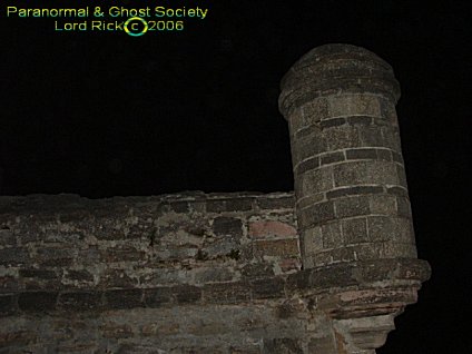
Night Photos Of The Fort & Port
The Harshness Of Rattle Snake Island Marshes, Debris, Woods, Fallen Trees, Hidden Paths, Creeks and Sand!
In accordance with Title 17 U.S.C. Section 107, any copyrighted work in this message is being distributed under fair use without profit or payment to those who have expressed a prior interest in receiving the included information for non-profit research and educational or criticism purposes only. Notwithstanding the provisions of sections 106 and 106A, the fair use of a copyrighted work, including such use by reproduction in copies or phone records or by any other means specified by that section, for purposes such as criticism, comment, news reporting, teaching (including multiple copies for classroom use), scholarship, or research, is not an infringement. Anotherwards a few photos are borrowed we do not make any profit off pictures mainly they are used for historical, criticism, theories and other educational purposes therefore we can use them as long as we do not claim them as our own or get paid for those photos specifically.
|
|
|
|
|
|